Maps
These maps are high resolution scanned images in Tagged-Image File Format (TIFF). TIFF is the preferred format because it is lossless. TIFF files are compatible with many programs. Microsoft Windows users will see good results with the 'Microsoft Imaging' application or any application with a 'zoom' capability. http://www.arkansashighways.com/Maps/Counties/1936/HistoricalMapst.htm
These maps show the township lines for most counties which when you are looking for census boundaries 1930 and before . They make an excellent reference resource. The URL will take you to the page where all 75 counties are listed but this is the download page.
|
Arkansas County Map |
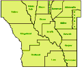
Township Map 1873 |
Township Map w/Grid 1873 |
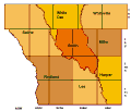
Township Map 1936 |
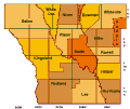
Township Map w/Grid 1936 |
 |
 |
 |
 |
 |
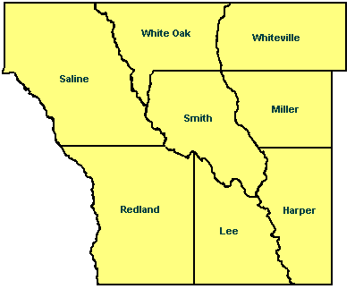
On 17 May 1873, the board of supervisors divided the county into eight political townships: Red Land, Lee, Saline, White Oak, Whiteville, Smith, Miller, and Harper. The boundaries of the several townships were established as follows:
- Red Land - Shall commence at the southwest corner of Dorsey County; Thence east to the southeast of Section 36, Township 11, south of Range 11 west; Thence following the Range line north to the Saline River; Thence with said River to the Township line between Townships 9 and 10, in Range 11 west; Thence with said Township line to the Moro Creek; Thence down said Creek to the point of beginning.
- Lee - Shall commence at the southwest corner of Section 31, Township 11, south of Range 10 west; Thence with the county line east to Saline River; Thence up said river to the point where said Saline River crosses the Range line between Townships 10 and 11; Thence south with said Range line to the point of beginning.
- Saline - Shall commence at the point where the Township line between Townships 9 and 10 crosses Moro Creek, and with said line east to the Saline River; Thence up said river to the northern boundary of Dorsey County, and with said boundary line west to the northwest corner of said county; Thence with the western side of side of said county to the point of beginning.
- White Oak - Shall commence on Saline River, at the mouth of Derreiseaux Creek; Thence up said Creek to the Township line between Townships 8 and 9; Thence with said line east to the Big Creek; Thence up said creek to the northern boundry of Dorsey County; Thence west with said boundary to the Saline River; Thence down said river to the point of beginning.
- Whiteville - Shall commence at the point where the Township line between Townships 8 and 9 crosses crosses the Big Creek; Thence east to the eastern boundary of Dorsey County; Thence north with said boundary line to the northeast corner of said county; Thence west with the northern boundary of said county to the Big Creek; Thence down said Creek to the point of beginning.
- Smith - Beginning on the Saline River at the mouth of Big Creek; Thence up said creek to the township line between Townships 8 and 9; Thence with said township line to Derreiseaux Creek; Thence down said Creek to the Saline River; Thence down said river to the point of beginning.
- Miller - Shall commence at the point where the Township line between Townships 9 and 10 crosses the Big Creek; Thence east with said township line to the eastern boundary of Dorsey County; Thence north with said boundary line to the township line between Townships 8 and 9; Thence with said township west to the Big Creek; Thence down said Creek to the point of beginning.
- Harper - Shall commence at the point where the southern boundary of Dorsey County crosses the Saline River; Thence with said boundary of said county east to the southeast corner of said county; Thence north with the east boundary of said county to the township line between Township 9 and 10; Thence west with said line to the Big Creek; Thence down said Big Creek to the Saline River; Thence down said river to the point of beginning.
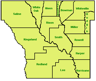
The parent counties where these eight original townships came from:
- Jefferson County: - Miller, White Oak and Whiteville
- Lincoln County: - Harper and Smith
- Bradley County: - Lee and Red Land
- Dallas County: - Saline
The county was later further divided to create five additional townships: Niven, Bowman, Prairie, Tisdale and Hurricane
- Niven - Formed 6 Oct 1873 from White Oak township of Dorsey county, land formerly in Jefferson county
- Bowman - Formed July 1878 from Whiteville and Miller townships of Dorsey County, land formerly in Jefferson County
- Prairie - Formed 20 July 1874 from Saline and Red Land townships of Dorsey County, land formerly in Dallas County and Bradley County
- Tisdale - Formed 8 Apr 1884 from Smith township of Dorsey County, land formerly in Lincoln County.
- Hurricane - Formed 5 Aug 1878 from Harper township of Dorsey County, land formerly in Lincoln County
Other Township Boundary Changes:
- Oct 1875 - part of Lee annexed to Red Land
- 3 Jan 1881 - part of Red Land added to Smith
- 7 Oct 1884 - part of Lee and Prairie added to Red Land
- Jul 1886 - part of Red Land annexed to Prairie
Kingsland, Rison and others were also added at later dates. |