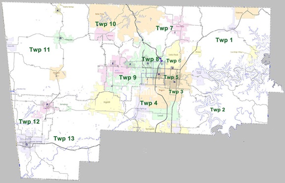
Benton County now uses numbers instead of names for their townships:
- Township 1:
- All of Garfield, Gateway, Lost Bridge Village, Prairie Creek;
parts of Avoca, Rogers.
- Township 2:
- Small parts of Lowell, Rogers, Springdale.
- Township 3:
- Parts of Lowell, Rogers, Springdale; most of Bethel Heights.
- Township 4:
- All of Cave Springs; most of Lowell, Rogers, Springdale (within Benton County); small parts of Elm Springs.
- Township 5:
- part of Rogers.
- Township 6:
- most of Little Flock, almost half of Avoca; small parts of Bentonville, Pea Ridge, Rogers.
- Township 7:
- most of Pea Ridge; part of Bella Vista; small part of Bentonville.
- Township 8:
- part of Bentonville.
- Township 9:
- most of Bentonville, Centerton; small part of Highfill.
- Township 10:
- Most of Bella Vista, Hiwasse.
- Township 11:
- all of Cherokee City, Decatur, Gravette, Maysville, Sulphur Springs; small parts of Centerton, Highfill, Hiwasse.
-
Township 12:
- most of Gentry; more than half of Siloam Springs.
- Township 13:
- all of Springtown; most of Highfill; small parts of Elm Springs, Gentry, Springdale.
Sources: Alamy.com and
Wikipedia.org
