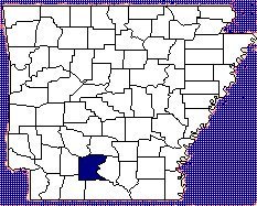
Hist Camden & Oua

Ouachita County

History


Ouachita County has 733 square miles of gently rolling upland and fertile valley
land and was once considered to be one of the best agricultural counties in South
Arkansas. As part of the Coastal Plain, the mean temperature in January is 43 degrees
and in July 82. The mean annual rainfall is 53 inches.

Current county population is 30,547. Camden's city population is 14,380. Today the
county economy is about half timber-based and half manufacturing, with some
tourism thrown in. The Southern boundary of the county is about forty miles from
the parallel boundary of Louisiana and Arkansas. Camden is about 100 miles due
south directly below Little Rock, Arkansas.

The county was created by the act of Governor Archibald Yell on November 29, 1842 from the northwestern part of Union County and was named for the river which flows through it.


Present day Ouachita County area was originally the land of the prehistoric Indian
mound builders, and later the headquarters of the Arkansea, or Quapaw Indians, a
branch of the Sioux tribe who settled south of the Arkansas River in the Middle Ages.
It would have been the Indians that guided Hernando De Soto in his historic trip up
the Ouachita River in 1541. Historians show that he spent the winter of 1541-1542 at
an Indian village somewhere within the bounds of Union County nearby.

Marquis de Maison Rouge was issued a tract of land in 1797 lying along Bayou
Bartholomew on the Ouachita River where the town of Camden came into being. The
first permanent settlement, other than the native Indians, was made at what was
called Frenchport, some 15 miles below the present site of Camden on the Ouachita
River. The first settlers were Frenchmen, who came to hunt, trap and trade with the
friendly tribe of Quapaws who occupied the land. Among those early settlers was a
navigator named Fabre, who settled 15-18 miles nearer the head of navigation in the
early 1800's . The site became knows as Ecore a Fabre (Fabre's Bluff) because the land
on the west of the river formed great bluffs which overlooked the river. His river
landing became a chief trading post.


By 1818/1819 so much interest in this locality had been generated, the the friendly
Quapaws were persuaded to agree in a treaty to relinquish this area called
"Arkansaw County". When Arkansas became a Territory, created out of the Territory
of Missouri, by act of Congress on March 2, 1819, the area, which later became
Ouachita County, was at that time contained in what was called Hempstead County
and Ecore Fabre was a township of Hempstead. During this year (1819) the Tate
brothers - Andrew, Richard and George - came up the Ouachita in keel-boats with
their families. Then low water and a sand bar forced them to stop on the banks of the
Ouachita. George Tate eventually settled three miles northeast of Fabre's Landing
and his family was the first to cultivate land in the area.


In 1824 the Quapaws ceded this area to the United States. Venturesome pioneers
began to flow into this part of the country rapidly, seeking new ground for their
crops, new territories for hunting and fishing, and with them they were bringing the
many crafts, skills and professions that would be needed to settle the land.

After Fabre died, a trapper, Jessee Bowman built a cabin on the area now covered by
downtown Camden. John Nunn, in 1824, came overland from Georgia with his
brother, his wife and four children and built a log house, the first home of permanent
nature at the site. The two brothers set out to run a line of boats up the Ouachita
River to Fabre's Landing, and pole the freight and passengers up to Washington,
Arkansas near the Texas border.

Five years after Nunn's arrival at Fabre's Landing, a new county was formed called
Union, on November 2, 1829 with Ecore Fabre being it's county seat. The area was a
river landing and hunting rendezvous up to about 1830, when Pargo of Monroe
started the first store down near the wharf, in an old log building. The Choctaw Indians lived nearby until about 1832 when they moved further west further opening the territory to settlers. Travel up to Washington on Ouachita River route was heavy up to about 1833. Small stores were opened "under the hill" near the prominent steamboat landing. In 1836 Arkansas was admitted into the Union. Governor Archibald Yell made Arkansas's forty-fourth county, Ouachita County, on November 29, 1842, carving it from the northwestern part of Union County and naming it for the river which flows through it.

As the county grew and prospered, the town site of Ecore Fabre was surveyed in
1839 - 1840. In 1843 when the county seat of justice - Ecore Fabre - was chosen, its
name was changed to Camden. At the suggestion of General Woodard it was
renamed after an old South Carolina city. Many new firsts came to the budding town:
Ira Nunn's cotton gin in 1841, the first Medthodist church in 1844, Chase & Wilson
started a carriage factory in 1858 and Merrill & McGill built the brick woolen mills
down near the landing. There was a great influx in the 1840's and numerous changes,
so that by 1848, there were probably 800 inhabitants lining the main thoroughfare of
Washington Street. In 1847 Peter McCollum, a merchant, built a home on a hill
overlooking an overland trade route West of the river business district. The home
later purchased by John T. Chidester became his home and headquarters for the
Chidester Stage Line. (See Mc-Collum-Chidester House). It was very common for
Washington Street to be crowded from one end to the other with cotton teams
awaiting their turn. As high as 40,000 bales a season were received. There is no doubt
that Camden was by far the greatest cotton mart in Southern Arkansas with as many
as four steamboats a day arriving to haul the cotton south to New Orleans. Once this
heavy steamboat traffic linked Camden directly to New Orleans and other important
cities. During this time the first newspaper, the Ouachita Herald had it's first issue on
November 6, 1845. The new town was incorporated on January 1, 1849 and elected its
first officials. As the town grew, other religious groups formed. Baptist and Catholic
were here by 1850 and the Presbyterian by 1852.

By 1860 the population of the county numbered 12, 396, the sixth largest in the State.
During the Civil War, the "Queen City" on the Ouachita was the strongest
Confederate point in southern Arkansas. In the Spring of 1864, the War Between the
States came to the major river port city. As federal General Frederick Steele was
leading his army from Little Rock to Shreveport, Louisiana as a part of a much larger
campaign to vanquish Confederate resistance in this area, he was unsuccessful in his
endeavors and brought his army to Camden. The city had been heavily fortified in
preparation for a Yankee assault, but the Rebel forces had withdrawn to west of
Camden to prevent Steele's advance on the Confederate state capitol of Washington.
As a result, Steele's army met little resistance in overtaking and then occupying the
town. Union troops occupied Camden for 13 days and were here during the time of
the Battle of Poison Springs west of town. It was in this Battle that determined
Confederate Soldiers gave the South their first victory in Arkansas forcing Steele and
his troops to retreat to Little Rock. The South Arkansas troops remained the sole
surviving military force of Arkansas until the war ended.

In 1881 the Iron Mountain Railroad entered and in 1883 the St. Louis Southwestern
Railroad (Cotton Belt Route) was completed. The Rock Island Branch was
constructed in the year 1911-12. The railroads were to provide access to the great
forests of pine and hardwood for which this part of the state was noted. As the
timberlands were cut down mill towns sprung up in the county. Among them were
Ouachita towns - Bearden, Chidester and Stephens.

The town of Stephens bears the distinction of being the location of the first producing
oil well to be drilled in Arkansas. The Hunter well on the Lester Haltom farm east of
Stephens came in early 1920.

After the turn of the century, manufacturing found it's way to Camden with
International Paper Company with Bagpak Manufacturing and Sales Division,
Southern Kraft Paper Mill and Woodlands Divisions. Other paper supplies were
manufactured by Gilchrist Bag Company; and furniture which bore the Camden
Furniture Company label and railroad ties from Gross and Janes were shipped
throughout the nation. Yearbooks for many of the leading colleges and universities
were produced, printed and bound by the Hurley Company.

Many locally manufactured products enjoyed a wide distribution, including Camark
Pottery which can still be found in antique stores today and is a much sought after
collectible. Camden was the central office for Grapette, and soft drink syrups were
shipped all over the world.

The construction of the Naval Ammunition Depot at Shumaker (now East Camden)
begun during World War II in 1945 caused many changes to the communities here.
The Depot was intended for the assembling and testing of rockets for use by the U. S.
Navy and other branches of the armed service. The land acquired for this endeavor
comprised about 69,000 acres taken from Ouachita and Calhoun Counties and
required the resettlement of hundreds of families. Private companies now own all of
the facilities and some defense contractors still occupy some of the locations there.
Camden is poised on the brink of the 21st Century with a firm appreciation for its heritage and an eye on new technology and modern industry.

History & Culture Table of Contents